
Robin’s story — The crew’s perspective
March 26, 2022
To fly or not to fly, that is the question
April 6, 2022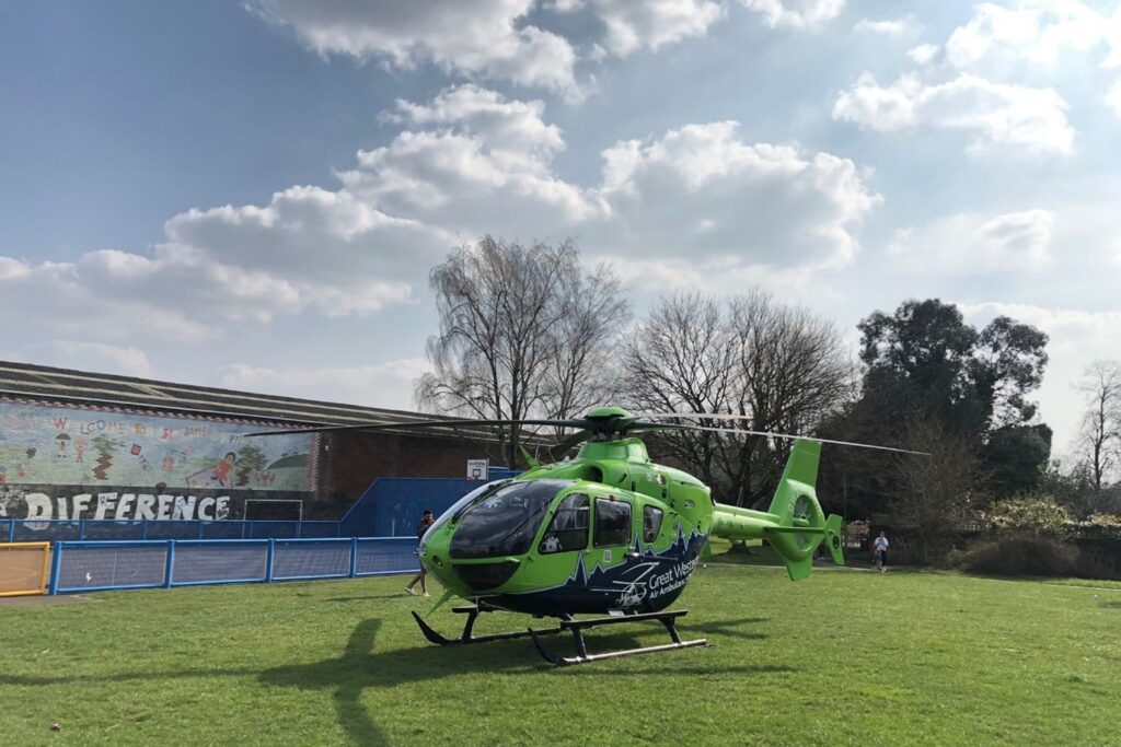
One of the challenges associated with Helicopter Emergency Medical Service (HEMS) operations is the selection of a safe landing site as close as practicable to the scene of an incident.
Great Western Air Ambulance Charity (GWAAC) Pilot, Alan Petch, has come up with an idea to minimise response times, facilitate integration with other emergency service assets and enhance flight safety.
The problem
On arriving overhead at a scene, the GWAAC crew must select a landing site and conduct a ‘recce’ to ensure the site is suitable. The recce involves an assessment of a potential site, including:
- Size
- Shape
- Surround
- Surface
- Slope
- Vehicular and pedestrian access routes
- Hazards associated with downwash generated by the rotor blades.
The challenge associated with landing site selection is particularly acute in densely populated urban areas and steep rural terrain. The GWAAC operating area includes an abundance of both!
Tricky landing areas
Captain Petch says that the most difficult landing areas in our region include:
“Dense urban areas such as central Bristol, Bath, and Gloucester… Put simply there just isn’t a great deal of open space available in these areas. Hazards associated with obstructions, downwash, people and vehicles are also more prevalent in an urban environment.
The most challenging rural area on our patch is the Forest of Dean. The woodland is very dense over significant portions of the forest and many of the clearings and forestry tracks are located on steep ground.
The Stroud valleys are also challenging because they combine a rural environment with steeply sloping terrain.”
The solution
To assist with flight planning, minimise response times, facilitate integration with other emergency service assets and enhance flight safety, GWAAC has established a database of potential landing sites throughout the charity’s operating area.
The “South West Rendezvous Directory” (SWRV directory) lists over 250 sites in Bristol, Bath, Gloucester, Cheltenham, the Stroud Valley, Weston-super-Mare and a number of other densely populated areas.
Sites included in the directory have been assessed to be large enough to accommodate Helimed 65, our EC135 helicopter, with each one having a minimum diameter of 25m. Inclusion of a site in the SWRV directory does not imply permission to land and our crews must conduct an airborne recce prior to landing in a similar manner to any other ad-hoc landing site
Identifying a new landing site
Alan says that maintaining and developing the SWRV directory is an iterative process. All sites are measured using Google Earth to ensure that they meet minimum size requirements.
Sites included in the initial version of the directory were identified using a combination of local knowledge and a systematic search of targeted urban areas using Google Earth. Further sites have been added following identification and use during live HEMS missions. Alan has also carried out ground recces of a number of sites.
When a SWRV directory site is used by Helimed 65, the pilot concerned updates a ‘resurvey matrix’. Any comments added to the matrix are included in the directory at the next update.
How the SWRV directory is saving lives
There are four main advantages of the SWRV directory, all of which help to increase a patient’s chance of survival:
-
Informed fly/drive decision-making
When response times by road and air are similar, the pilot can advise the Critical Care Team on how close he can get them to the scene in Helimed 65. This may result in the use of the aircraft in-lieu of a critical care car. The advantage of deploying by air in such circumstances is that the crew is better placed to respond to further tasking if required. In other words, it cuts out the return journey to base in order to rendezvous with the aircraft. For further information on the crew’s decision-making process, read our blog To fly or not to fly, that is the question.
-
Rapid identification of potential landing sites
Before conducting a recce, the crew must first identify a potential landing site as close to the scene of the incident as practicable. The directory enables the crew to select a potential landing site before departure from the base or when re-tasked in the air. Although still required to conduct a full recce, the directory provides a high degree of confidence that the selected site will be suitable. This has the potential to save time on arrival overhead at the scene of an incident.
-
Enhanced integration with SWASFT and other emergency service assets
There may be occasions when Helimed 65 cannot land close to the scene, or the crew must rendezvous with other emergency service assets prior to proceeding to the patient. The directory enables the GWAAC Critical Care Team to designate a rendezvous at an early stage in a mission.
-
Landing site access and security
Designating a landing site prior to arrival on-scene allows the crew to:
- Plan for egress from sites with restricted access (e.g. schools when they are closed at weekends and during holiday periods).
- If necessary, when it isn’t possible to land adjacent to an incident, plan a route from the landing site to the patient.
- Arrange landing site security at certain busy urban locations.
For example, we have an informal arrangement with pedal-a-bike-away cycle hire in the Forest of Dean, where they facilitate access to a landing site located in an adjacent Highways Agency compound. They also provide onward transportation for the Critical Care Team to incidents on the local mountain bike trails.
Another example is the service offered by the North Somerset Council Beach Rangers in Weston-super-Mare — we can request secure landing sites on the seafront by calling ahead to the local CCTV control room.
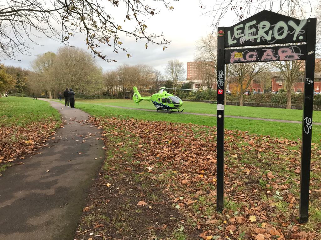
We’re already using the SWRV directory to help us land in urban environments. The centre of Bristol offers a very limited number of potential sites. Also, the time it takes to start up the helicopter, find somewhere to land, then get to the patient from that landing site can be outweighed by the shorter time it may take for our critical care car to drive straight into the city centre from Almondsbury via the M32.
On one occasion, the aircraft and crew were on the helipad at Southmead Hospital, having completed a patient handover. A call came in for a HEMS mission in St Pauls, central Bristol. The choice was to fly or not respond at all. Because of the SWRV directory, the crew knew they had a potential place to land at Riverside Park, St Agnes, so they deployed.
Future plans
Alan says, “We’ll keep adding sites to our database as and when we find them… It would be nice to see the project adopted by other air ambulance charities and HEMS operations. And it would be great to see my school initiative come to fruition in 2022.”
Alan’s “school initiative” will expand the SWRV directory with more sites located at schools and sports clubs. Access to such locations can be problematic at weekends and school holidays so GWAAC’s Supporter Engagement Team is in the process of building relationships with the relevant organisations to ensure ‘out-of-hours’ access.
Not only will the school initiative benefit people in need of critical care in our communities, but it will also benefit the schools themselves. Intrigued? More will follow on this endeavour, so keep your eyes peeled on our news page.

… Put simply there just isn’t a great deal of open space available in these areas. Hazards associated with obstructions, downwash, people, and vehicles are also more prevalent in an urban environment.
The most challenging rural area on our patch is the Forest of Dean. The woodland is very dense over significant portions of the forest and many of the clearings and forestry tracks are located on steep ground.
The Stroud valleys are also challenging because they combine a rural environment with steeply sloping terrain.”